A Comprehensive Travel Guide: Reykjavik to the Ring Road Highlights
This guide details a classic Icelandic itinerary, looping from the capital through the wild Westfjords, the volcanic Snaefellsnes Peninsula, the stunning South Coast, and back. It is designed to be driven over 7-10 days, offering a deep immersion into Iceland’s diverse landscapes.
Reykjavik: The Northernmost Capital
Reykjavik, the world’s northernmost capital, is a vibrant and colorful city that serves as the perfect starting point for any Icelandic adventure. It combines a small-town feel with cosmopolitan culture.
Key Attractions
Hallgrímskirkja Church: This iconic Lutheran parish church, towering over the city, is Iceland’s tallest building. Its unique design was inspired by the basalt lava flows common in Iceland’s landscape. Take the elevator to the top for a panoramic view of the city’s colorful rooftops and the surrounding mountains and sea.
Harpa Concert Hall: A architectural masterpiece on the waterfront, Harpa’s geometric glass facade reflects the sky and sea, creating a dazzling display. Even if you don’t attend a concert, wandering through its interior is a memorable experience.
Sun Voyager (Sólfar): This striking steel sculpture on the seaside promenade resembles a Viking longship. It is not a Viking ship but an “ode to the sun,” representing dreams, hope, and freedom.
Perlan (The Pearl): Located on Öskjuhlíð hill, this glass-domed structure offers another excellent viewing platform. It also houses a natural history museum and a remarkable indoor ice cave.
The Old Harbour: A hub of activity, the old harbour is the departure point for whale watching, puffin tours, and ferry trips to Viðey Island. It’s also filled with excellent seafood restaurants and shops.
Practical Information
Accommodation: Wide range from luxury hotels like Canopy by Hilton to budget-friendly hostels and guesthouses. Book well in advance, especially in summer.
Dining: Try traditional Icelandic fare like lamb soup or venture into the world of New Nordic cuisine at restaurants like Dill or Fish Market. Don’t miss the famous hot dogs at Bæjarins Beztu Pylsur.
Getting Around: The city center is very walkable. For attractions further out, the Strætó bus system is reliable, or you can use a rental car.
Borgarfjörður: Waterfalls and Viking Sagas
Driving north from Reykjavik, the Borgarfjörður region is a lowland area rich in history and natural beauty, famously connected to the Icelandic Sagas.
Key Attractions
Deildartunguhver: The most powerful hot spring in Europe, with a flow rate of 180 liters per second of boiling water (100°C/212°F). The steam rising from the earth is an impressive sight.
Hraunfossar and Barnafoss: A series of stunning, serene waterfalls where water emerges from underneath a vast lava field (Hallmundarhraun) and flows in countless streams into the Hvítá river. Nearby, Barnafoss (“Children’s Falls”) is a powerful rapid with a tragic legend.
Reykholt: A historical site that was once home to Snorri Sturluson, Iceland’s most renowned medieval scholar and chieftain. You can visit his pool (Snorralaug) and a cultural center dedicated to his work, including the Prose Edda and the Heimskringla.
Practical Information
Accommodation: Several charming guesthouses and farm stays in the area, such as those in Reykholt or near the waterfalls.
Driving: An easy drive on Route 1 and then paved regional roads. A great stopover on the way to the Snaefellsnes Peninsula.
Snaefellsnes Peninsula: Iceland in Miniature
Often called “Iceland in Miniature,” this dramatic peninsula packs glaciers, volcanoes, black sand beaches, charming fishing villages, and lava fields into one concentrated area, crowned by the glacier-capped stratovolcano Snaefellsjökull.
Key Attractions
Kirkjufell Mountain: Arguably Iceland’s most photographed mountain. Its distinct arrowhead shape rises dramatically beside the Kirkjufellsfoss waterfalls. Best photographed from the east side during sunset or under the Northern Lights.
Snaefellsjökull National Park: Centered around the Snaefellsjökull glacier, which Jules Verne made famous as the entrance to the center of the Earth in his novel. The park features diverse landscapes including the rugged Lóndrangar basalt cliffs and the unique Vatnshellir lava cave.
Arnarstapi and Hellnar: Two picturesque coastal villages connected by a beautiful coastal hiking trail. Marvel at the natural stone arch and the dramatic basalt column formations at Arnarstapi.
Djúpalónssandur and Dritvík: A hauntingly beautiful black sand and pebble beach littered with the rusted remains of a shipwrecked British trawler. Here, you can test your strength on the four historic “lifting stones” used by fishermen.
Stykkishólmur: The main town on the peninsula, with a colorful harbor, a modern church, and a distinctive orange-and-white lighthouse. It’s a great base for exploring and offers ferry connections to the Westfjords.
Practical Information
Accommodation: Options range from hotels in Stykkishólmur to guesthouses and cottages in smaller villages like Grundarfjörður and Hellissandur.
Dining: Excellent seafood is a given. Try Narfeyrarstofa in Stykkishólmur for a fine dining experience or Bjargarsteinn Mathús in Grundarfjörður.
Driving: The circular route around the peninsula is well-paved (Route 54 and 574). Allow at least one full day, but two days are recommended to explore thoroughly.
The South Coast: Waterfalls, Black Beaches, and Glaciers
The journey along Iceland’s South Coast on Route 1 is one of the world’s most spectacular drives, featuring an almost continuous parade of waterfalls, vast sand plains, glaciers, and volcanic beaches.
Vík í Mýrdal
A small village that serves as the southernmost point in Iceland. It is dramatically situated beneath the Mýrdalsjökull ice cap, which covers the Katla volcano.
Reynisfjara Black Sand Beach: A world-famous beach known for its pitch-black sand, towering basalt sea stacks (Reynisdrangar), and the immense Hálsanefshellir cave. Extreme caution is required due to “sneaker waves” – powerful, unexpected waves that can drag people out to sea. Always keep a safe distance from the water.
Reynisdrangar: The iconic basalt stacks rising from the ocean just off the shore. Legend says they are two trolls who were turned to stone when caught by the sunrise.
Dyrhólaey: A massive stone archway protruding into the sea. This promontory offers stunning views of the coastline and is a popular nesting site for puffins (May to August).
Practical Information
Accommodation: Vík has a hotel, a hostel, and several guesthouses. It’s a popular stop, so book early.
Services: Vík has a well-stocked supermarket, a gas station, and a wool factory outlet (Icewear).
Höfn & The Glacier Lagoon Area
The area east of Vík becomes increasingly dominated by glacial rivers and massive ice caps. The small town of Höfn is known for its langoustine, but the main attractions lie just beyond.
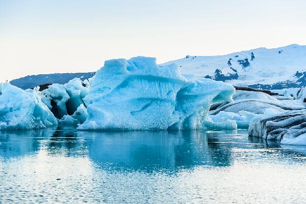
Jökulsárlón Glacier Lagoon
A breathtaking glacial lagoon filled with icebergs that have calved from the Breiðamerkurjökull glacier, an outlet of Europe’s largest ice cap, Vatnajökull. The icebergs float serenely in the deep blue lagoon before drifting out to sea. It is one of Iceland’s most famous natural wonders.
Boat Tours: Take an amphibian boat or a zodiac tour to get up close to the icebergs. Tours are highly recommended and operate from May to October.
Wildlife: Seals are frequently seen swimming in the lagoon or resting on the ice.
Diamond Beach
Directly across the road from Jökulsárlón, where the lagoon meets the Atlantic Ocean via a short channel. Icebergs that wash ashore are scattered across the black sand beach like glittering diamonds, especially at sunrise or sunset. The contrast between the clear ice and the black sand is utterly mesmerizing.
Practical Information
Accommodation: Limited options near the lagoon itself; most visitors stay in Höfn (about an hour’s drive east) or at nearby guesthouses and hotels like Hótel Skaftafell or Fosshótel Glacier Lagoon.
Tours: Book boat tours on Jökulsárlón in advance during peak season.
Sustainability: This is a fragile environment. Do not walk on the icebergs on Diamond Beach and follow all posted guidelines.
Other Key South Coast Stops (West of Vík)
Seljalandsfoss:A beautiful waterfall where you can walk on a path that goes completely behind the cascading water. Wear waterproof clothing! Just east of it is the hidden gem Gljúfrabúi, a waterfall hidden inside a canyon.
Skógafoss:A massive, powerful waterfall with a 60-meter drop. You can walk right up to its base and feel the spray. A staircase leads to a viewing platform at the top for a spectacular view of the coast.
Sólheimajökull:A stunning outlet glacier from Mýrdalsjökull. It’s an accessible place to see a glacier tongue up close and even join a guided glacier hike.
The Eyjafjallajökull Volcano:The famous volcano that erupted in 2010, disrupting air travel across Europe. Learn about it at the Þorvaldseyri Visitor Centre or see its ice cap from various viewpoints.
General Practical Travel Information
When to Visit
Summer (June-August): Midnight sun, warmer temperatures (10-15°C / 50-59°F), all roads and services are open. This is peak tourist season; it’s busy and most expensive.
Shoulder Seasons (May & September): Fewer crowds, lower prices, decent weather. A great balance. Northern Lights become visible from late August.
Winter (October-April): Experience only a few hours of daylight, but chances to see the Northern Lights are high. Weather can be severe, and some roads (especially in the highlands) are closed. A 4×4 vehicle is often necessary.
Transportation
Rental Car:The most flexible way to explore. Book months in advance.
- A 2WD car is sufficient for this itinerary in summer if sticking to main roads (Route 1).
- A 4×4 is recommended for winter travel or if you plan to venture onto F-roads (mountain roads).